MEDIEVAL PATHWAY ROUTE TO BANDUJO - PROAZA - ASTURIAS - SPAIN
Hiking Trail: Lineal
Itinerary: Senda del Oso - Bandujo - Senda del Oso
Distance: 5 km aprox. round trail
Timescale: 2 h. at a slow pace
Difficulty: Easy
Height difference: 300 m.
On MTB: No
Kids: Sí
Date Completed: 22/11/2012
Location: AS-228, 33114 Proaza, Asturias, España
TRACK OF THE ROUTE
This beautiful route runs along the old medieval path that connects the village of Bandujo to the road to Proaza and was used by the villagers before the road was built.
To get to the start of the route we have to go towards Trubia, following the AS-228 and once crossed Proaza, we´ll arrived at Caranga de Abajo,turning right continuing on the AS-228 for approximately 1.5 km, then at a curve to the left we leave the car beside the signal indicator and Ventana Puerto San Martin de Teverga. To get there see LOCATION
A few meters from this point up to the bus stop, cross the River Teverga by a concrete bridge, accessing the Bear Trail ...
.JPG)
Then descending for about 50 meters along the left bank of the river, we reach this point where a sign indicates the beginning of the path to the medieval village of Bandujo (Banduxu)
.JPG)
In this map we leave the profile of the route, which as you can see has a good slope although quite short. The profile is on the way back, so first you have to ascend.. A small unimportant detail.
 |
| Medieval Trail Map to Bandujo Village Proaza - Asturias - Spain |
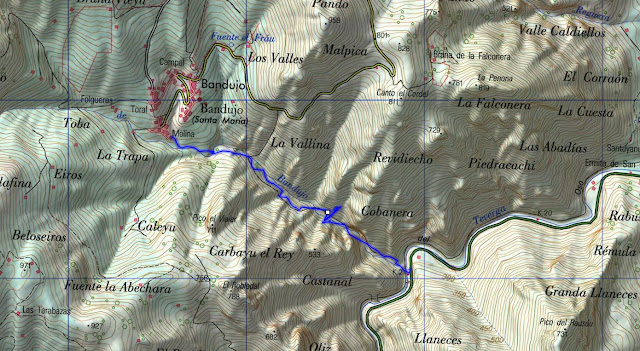
And in this one you can see the route on a topographical map. I activated the Gps on the way back, although the route has not lost since it follows the medieval path all the way and there are no forks in all the way.
 |
| Topographic map Of the trail to Bandujo |
This beautiful route runs along the old medieval path that connects the village of Bandujo to the road to Proaza and was used by the villagers before the road was built.
At the start the way we move into a small gorge along most of the trail by the river at this time Valmoro that had not much water though which does not lose its charm, enjoying some of them numerous waterfalls hopping up to 10 meters high.
.JPG) |
| Waterfall in the Medieval path to Bandujo - Proaza - Asturias |
Along the trail we crossed numerous wooden bridges till we reach this one. From here the trail gets quite steep buy just for about five hundred meters.
.JPG) |
| Medieval pathway to Bandujo in Asturias Spain |
In this photo you can see how little water carries the stream at this time of year, hopefully in a few weeks it will get torrential.
.JPG) |
| Small Waterfall at Valmoro Creek Spain |
.JPG) |
| Chestnut forest Asturias |
This is the most outstanding part of the way, as you can see, is completely paved. With moisture and leaves must take a little care, especially in the fall.
Surprisingly, a route as pretty as this, being so close to the popular Bear Trail "Senda del Oso", is not widely known. To me it reminds a lot to the Mythological Route of Beyu Pen in Amieva. With its native forest and the stream we followed in much of the way.
Typical Asturian House in the Molina neighborhood in Bandujo
.JPG) |
| Bandujo - Proaza - Asturias |
This photo from Bandujo Village was taken from the track that climbs up to Caldoveiro peak and Cuevallagar, and it highlights the tower known as Tower or Bandujo Tuñón. One of the Best preserved Medieval Tower of Asturias.
 |
| Medieval Bandujo Village Asturias Spain |
Back in the way back...
.JPG) |
| Small cascade at Valmoro Creek Asturias |
Here you have the TRACK OF THE ROUTE although the path not lost, you can help to get an idea of the distances. Comment I recorded the track shortly after starting the descent, just take that into account.
We hope you enjoyed the ride.
greetings
PynAstur

.JPG)
.JPG)
.JPG)
.JPG)
.JPG)
.JPG)
.JPG)
.JPG)
.JPG)
.JPG)
No comments:
Post a Comment